NEW ORLEANS – The University of Colorado in Boulder revises its forecast every year for the Atlantic Hurricane Season in the beginning of August, and this year’s revision is not what we want to hear.
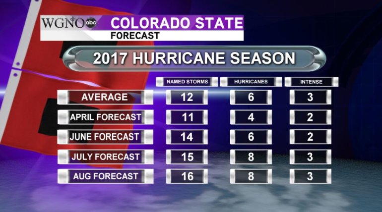
Look at the table below to see a rising trend. As of April, 11 named storms were forecast. By June that number had risen to 14. One month in July, the number had risen to 15 and now in August, the forecast is for 16 named storms, eight hurricanes and 3 major hurricanes. But why the increase?

Granted, it’s not a huge increase, but 16 named storms is well above the average of 12. It’s not often we would get to the letter ‘P’ when naming tropical systems in the Atlantic. One of the major factors is the fact that a weak El Niño that was expected to develop has yet to materialize.
El Niños typically will repress tropical activity in the Atlantic due to increased wind shear over the region which makes it difficult for systems to develop tropical characteristics. The Pacific Ocean off the coast of South America has remained in a neutral phase, neither El Niño or La Niña, and is expected to remain that way throughout the rest of the 2017 Hurricane Season for the Atlantic.
So far there have been five named storms already in the Atlantic, with Cindy already having impacted the Louisiana area and the oil rigs off the Gulf Coast. On average, the fifth named storm occurs around Aug 31. As for a hurricane, we have yet to see one in the Atlantic Basin so far in 2017. The average first date for a storm to reach hurricane status in the Atlantic occurs on August 10.
Forecasts aside, only Mother Nature knows for sure what will happen the rest of the year. Regardless, it only takes one storms to ruin property, lives and communities, so have you hurricane plans ready NOW.


