Overnight Monday into the early morning hours, between two and six inches in rainfall totals fell throughout Orleans, Jefferson, and beyond.
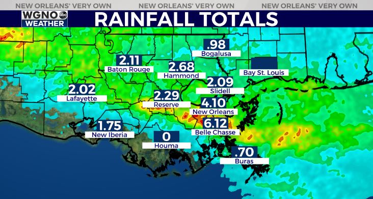
Extremely heavy rainfall rates fell between 3 a.m. and 6 a.m. leading to tons of widespread street flooding throughout Metaire as well as Kenner and River Ridge.
Four to eight inches in just a few hours is simply too much rain for many pump systems to keep up with, but it all drained by 10 a.m.
We have a stormy pattern in our forecast for Tuesday as well as Wednesday. Heavy rain will likely fall once again late tomorrow to early Wednesday morning, setting up similarly to this morning’s event. Plus, grounds are saturated, too, to make rainfall totals build up even faster.
Later tomorrow to early Wednesday, there’s the chance several of these storms could even become severe. Right now, Storm Preditction Center is issuing a Marginal Risk (Level 1/5) for all of WGNO’s viewing area until mid-week.
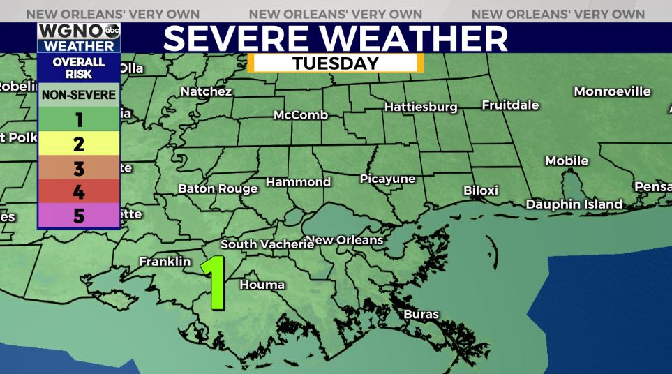
Summarized, the primary concern through late Tuesday will be heavy rain in already saturated locations, which could lead to localized street flooding once again in Jefferson, Orleans, or Northshore locations.
Gusty winds are a concern, as well. Stormier patterns stick around through mid-week, so have ways you can receive warning information on hand incase anything is issued!
Keep up, updates will remain available online on WGNO.com and tonight during WGNO News at 5PM, 6PM, and 10PM!
Check out current conditions near you: https://digital-staging.wgno.com/weather/new-orleans-weather-radar/
Stay up to date with the latest forecast: digital-staging.wgno.com/weather/forecast/
Download the WGNO Weather App to stay connected this hurricane season