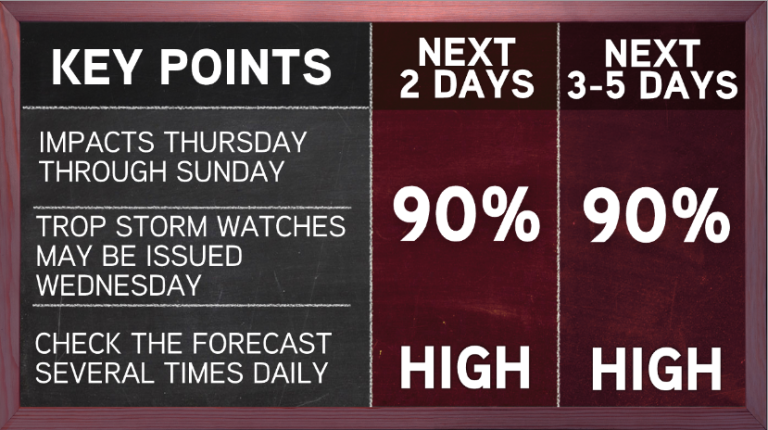
The National Hurricane Center is now giving an area of disturbed weather in the Northeast Gulf of Mexico a high likelihood 90% chance of developing into Tropical Storm Barry by Thursday morning.
Hurricane Hunters are scheduled to investigate the disturbance Wednesday at 1PM, if necessary.
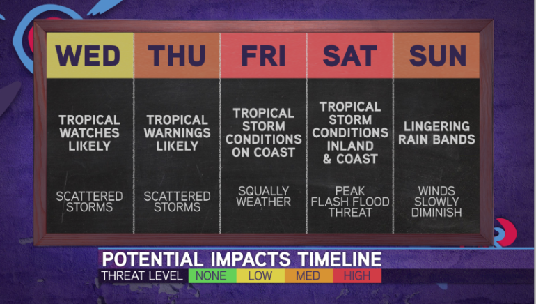
Very possible that we see Tropical Storm or Hurricane Watches issued for parts of the Gulf Coast by tomorrow, since Tropical Watches are issued 48 hours in advance of the onset of tropical storm force winds.

The exact path, intensity, and detailed impacts remain unclear. However, details will begin to become more clear tonight into tomorrow as the system attempts to organize…
Regardless, there is growing concern for significant impacts Louisiana Thursday night-Sunday…primarily for rainfall, but also the potential for some wind & coastal flooding.
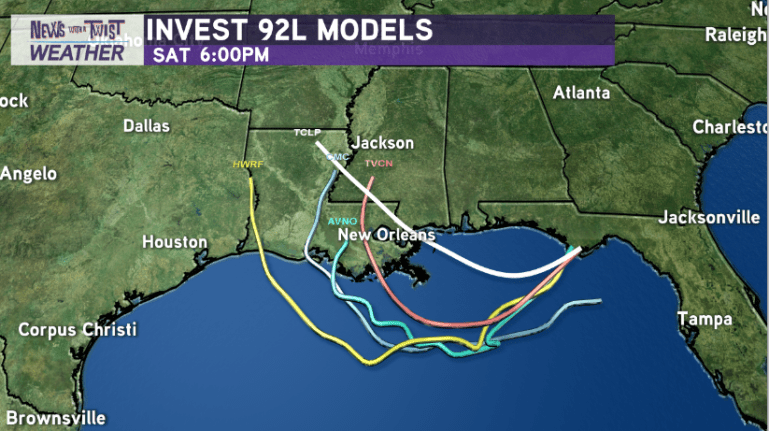
According to the latest European Ensemble Models from this afternoon, the system could trek anywhere between Galveston, Texas to the MS/LA state line. That represents a LARGE amount of uncertainty in the projected path…but a majority of the latest ensembles bring a significant threat for heavy rainfall to Louisiana.

If the system does indeed trek further west towards LA/SE TX…more time over warm water could give the system an opportunity to strengthen into strong tropical storm or even a hurricane. That’s something to pay close attention to.

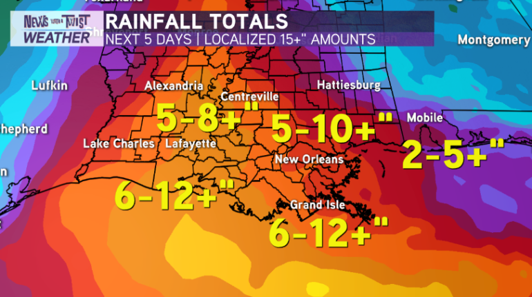
RAINFALL PROJECTIONS — Clear your storm drains! Not a trend we like to see along the northern Gulf Coast. We’re far away from the exact details being ironed out as far as Invest 92L’s future path and strength. However, one thing that continues to become more clear…heavy rainfall and flash flooding will be a big concern for many from this system regardless of strength.
Three of our most frequently used Global Forecast Models(GFS, EURO, and Canadian) are all converging towards a consensus of widespread 4-8+” of rainfall across south Louisiana, Mississippi, Alabama, and southeast Texas. With hot spots receiving 10-20+ inches of rain along and just east of a likely Tropical Storm or even Hurricane Barry between Thursday night-Sunday.

Get prepared!
What can you do to prepare at this point? Simple things. First and foremost, check the forecast numerous times daily for the latest details from a trustworthy source. Secondly, Re-stock your hurricane safety kit i.e. batteries, food, gasoline, water, flashlights. Clear out your storm drains, trim tree branches that are near the house & around power lines.
As always, the specifics will undoubtedly change and continue to become more precise once an actual system develops. As always, I’ll have more updates to come! Stay tuned!


