Happy Saturday! It’s the perfect evening to light the fireplace & roast s’mores! Light freeze expected north of Lake Pontchartrain.
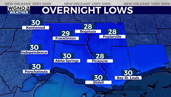
No pipe issues, but protect pets & plants. Make sure pets have a warm place to sleep!
![]() NORTH-CENTRAL LOUISIANA
NORTH-CENTRAL LOUISIANA![]() — Take some pictures for your neighbors down south Sunday night-Monday morning! High-res forecast models showcase 1-3” of accumulation from north of Alexandria towards Natchitoches/Ruston possible with isolated hot spots of 4-6+” possible.
— Take some pictures for your neighbors down south Sunday night-Monday morning! High-res forecast models showcase 1-3” of accumulation from north of Alexandria towards Natchitoches/Ruston possible with isolated hot spots of 4-6+” possible.
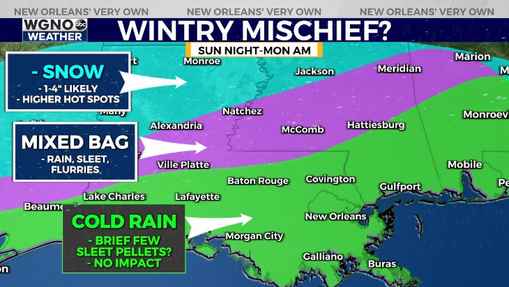
Models may be slightly overdoing snow amounts due to mixture with sleet. Expect travel issues Sunday night-Monday morning. Please be careful!
South Louisiana ![]() — We’re looking a bit too warm this go around. A few sleet pellets & flurries not out of the question for areas north of I-12. No accumulation expected.
— We’re looking a bit too warm this go around. A few sleet pellets & flurries not out of the question for areas north of I-12. No accumulation expected.


