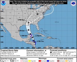
As of the 4 PM National Hurricane Center update on Tropical Storm Nate, only slight adjustments have been made. Nate remains a tropical storm with maximum winds of 40 mph, and has nudged slightly more northward, now moving to the NNW at 10 mph.
Tropical Storm Nate will soon re-enter the Caribbean before brushing the edge of the Yucatan Peninsula of Mexico overnight Friday and into early Saturday. Once Nate makes it into the Gulf of Mexico we will see strengthening, and it may become a hurricane by mid day Saturday.
Nate is still expected to make a northern Gulf landfall likely in Eastern Louisiana by Sunday morning as a strong tropical storm, or Category 1 hurricane. Nate will have a faster forward speed by the time it enters the northern Gulf, and will also interact with slightly cooler water temperatures in the Gulf, which may weaken the storm marginally by landfall.
The biggest impacts from this system continue to be storm surge and coastal flooding, tropical storm force winds, and isolated tornadoes. While not a tremendous amount of rain is expected, 2-4″ is possible. Nate is expected to lift northward into Mississippi by Sunday afternoon.

