Tropical Storm Barry continues to move extremely slowly to the northwest on Saturday morning. While very close to the coast in terms of actual distance, the slow movement means Barry is still several hours away from landfall as of 5 AM. The storm remains at 65 mph intensity.
Storm surge will continue to be an issue through at least early afternoon due to the slow movement of the storm. Coasts that are south facing will see high water levels, the highest being closer to the center.
The center is still struggling to full wrap up with the heaviest rain still south and southeast of it. Isolated heavy bands are well east of the center as well impacting southern Mississippi and Alabama. Tropical storm force wind gusts are being felt across southeastern Louisiana.
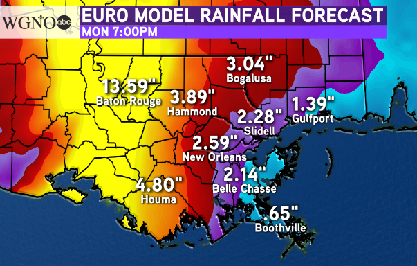
The overall theme of the impacts from Barry remain the same as the past couple of days. The heaviest rain will be near the center to the east and southeast.  The latest European forecast model, which has remained more accurate through the duration of the storm, puts the highest rain amounts in a corridor from Morgan City to Baton Rouge with decreasing amounts as you head east. The one thing to note here is that this is not picking up on rain from bands east of the center. There is a high likelihood that one or two bands will develop through the day and drop locally heavy rains within a narrow corridor.
Otherwise, outside of the band potential, most of the area does not appear to be under a threat of significant rainfall or flash flooding.
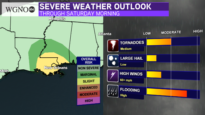
 A threat for tornadoes will persist Saturday through Saturday night. With the rain being more spotty over southeast Louisiana and southern Mississippi warmer temperatures and some sun will contribute to more instability. This means heavy tropical showers through the day with the threat of an isolated tornado. These will move very quickly so if you are located within a tornado warning take shelter immediately.
The threat of some isolated heavy rain will continue Sunday while the storm continues to move north and northeast. But as a whole, the heaviest amounts will stay more in the central part of the state.


