Happy Monday as yet another beautiful one returns across New Orleans and southeast Louisiana. Temperatures will rise out of the 50s into the 70s by this afternoon.
We will stay dry today, but clouds build back in by the evening ahead of our next weather system. Expect winds to pick up out of the south and southeast, helping bring in warmer, more humid air throughout the day.
The next rain chance is tomorrow. We are continuing to monitor the development of our next storm system as models show it bringing heavy rain and severe storms to Louisiana and Mississippi.
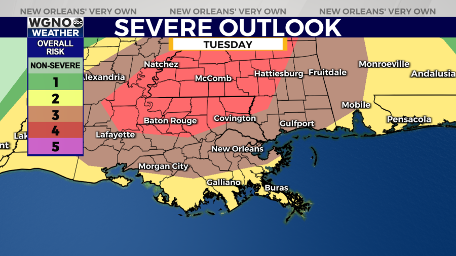
A large area near the Louisiana and Mississippi state line has been placed under a “Moderate Risk” for severe weather, which is threat level 4 out of 5 on the Storm Prediction Center’s scale. To the south, most of the Mississippi Gulf Coast and New Orleans metro have been placed under an “Enhanced Risk” (threat level 3 out of 5).

It is still too early to pinpoint exact timing with our high-resolution models, but it appears the bulk of the storms will move through in the afternoon or evening.
Right now, the main threats look to be damaging wind gusts and tornadoes, mainly for areas farther inland. The flood threat is low, but there may still be some minor street flooding, especially in areas that are low-lying or may have poor drainage.
Heading into Tuesday, make sure you have multiple ways to receive watches and warnings when they are issued. Stay up to date with the latest forecasts on air with WGNO and online at digital-staging.wgno.com.


