Patricia — the strongest hurricane ever recorded — barreled closer and closer Friday to Mexico’s Pacific coast, where residents have been told to brace for its 200-mph sustained winds and torrential rains.
The storm is expected to roll over Mexico’s Sierra Madre, its intense winds likely dulling and rapidly in the process. But much of the system’s precipitation could roll into the Gulf of Mexico before making its way up to Louisiana, Arkansas, and Texas, states already enduring heavy rains from another system.
Patricia’s potential path across the United States:

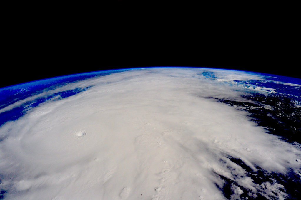
All eyes are on the massive Category 5 Hurricane Patricia heading for the western coast of Mexico. Packing 200mph winds and an incredibly low pressure of 880mb, Patricia is the now the strongest hurricane on record in the National Hurricane Center’s area of responsibility which includes the Atlantic and the eastern North Pacific basins.
Its central pressure reading — the weight of the air above a system — which is a key measure of any storm’s strength.
The early Friday central pressure recording of 880 millibars (the barometric pressure equivalent is 25.98 inches) “is the lowest for any tropical cyclone globally for over 30 years,” according to the Met Office, Britain’s weather service.
Patricia’s intensity is comparable to Typhoon Haiyan, which hit the Philippines in 2013, the World Meteorological Organization tweeted. More than 6,000 people died in Haiyan, due largely to enormous storm surges that rushed through coastal areas. Haiyan had 195-mph sustained winds when it made landfall, while Typhoon Tip was at 190 mph (and had a slightly lower pressure reading of 870 millibars) in 1979.
Whether or not Patricia measures up to those Asian typhoons when it slams Mexico, CNN meteorologist Chad Myers said, “This is the only hurricane that’s ever been this powerful.”
The closest contender, at this point, might be Hurricane Camille, which battered the U.S. Gulf Coast in 1969. Patricia looks to be more powerful than that storm, as well as stronger than Hurricane Andrew in 1992, Katrina in 2005 and many others.
El Nino contributes to storm’s strength
Still, while the Patricia-related rainfall could be significant in the United States, it pales to what people in Mexico will experience.
Those on that Latin American country’s west coast are no stranger to tropical storms, of course. But Patricia is special, in part because of the global, regular weather phenomenon known as El Niño.
Among other effects, El Niño has contributed to ocean waters off Mexico being 2 to 3 degrees warmer than usual.
“That warm water from El Niño probably just pushed this slightly over the edge to be the strongest storm on record,” CNN’s Myers said.
About the only good news about Patricia, as of early Friday afternoon, was that its center was fairly compact, with hurricane-force winds only extending 35 miles out from its eye.
That’s a plus for anyone who gets brushed by the hurricane, but no consolation for those who get hit directly.
“That’s almost like an F4 or F5 tornado that can be 5 or 6 miles wide, just tearing up the coast as it makes landfall,” said Myers. “… Can you imagine being the center of this eye, … and then get hit by the eye wall doing 200 mph?
“It will be a devastating blow.”