Today, the forecast for New Orleans and southeast Louisiana was cooler with scattered rain in the area keeping temperatures and feels like temperatures only slightly above normal.
Afternoon downpours, thankfully, provided temporary relief from extreme heat at times. Highs, themselves, reached mid 90s again but felt more like 100s. Overnight, over both sides of Lake Pontchartrain, expect 70s.
Thursday into your weekend, there’s the guarantee we see additional scattered downpours! 80% chances remain the theme. Tomorrow, showers for brief relief are a little more widespread as more than half of the area can expect heavy rain. Street Flood Advisories will likely occur, so maintain caution on roads and enable your emergency alerts.
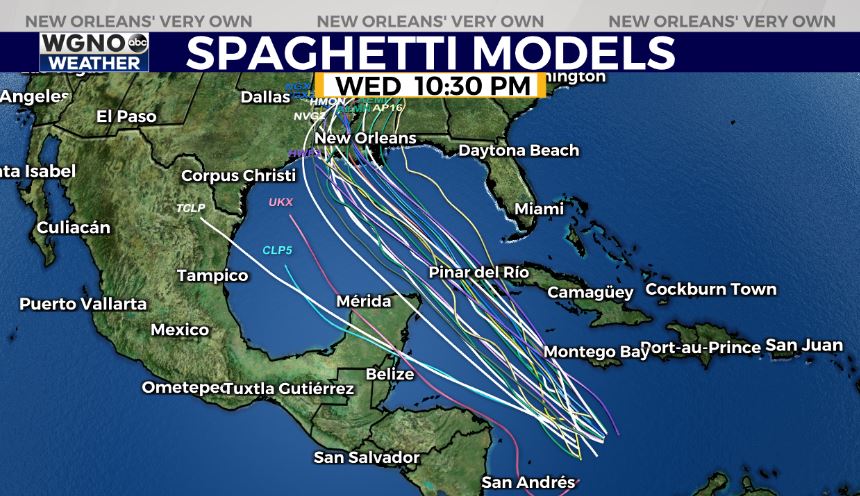
Tomorrow to Friday, we are closely monitoring the forecast for Tropical Wave Invest 99-L as it tracks near the Yucatan Peninsula. Right now, the National Hurricane Center gives this broad area of low pressure 60% chances for formation over these next 48 hours, but it will likely become Ida by your weekend. Right now, no defined center has formed, so exact track details are tough to pinpoint.

The dominant high pressure sitting over America’s East Coast will steer this storm northwest, meaning Texas, Louisiana, and Mississippi coastlines should pay close attention to our forecast for the next few days. Where 99L’s center develops will directly impact the eventual landfall point. If this forms more north of the Yucatan Peninsula, the storm will enter warm Gulf waters with a more likely path towards Louisiana. If this forms closer to southern Yucatan, the track would likely end up more west. Models will continue to change, so just remain in the know.
The Hurricane Hunters are scheduled to fly their first mission on this system Thursday afternoon if necessary for additional data.
Lead time looks minimal as a landfall could happen late this weekend or early next week, possibly as soon as Sunday night into Monday. The system will enter a favorable environment for strengthening with high Gulf of Mexico temperatures and minimal wind shear. Prepare for a hurricane at landfall. Remember categories are based only on wind speeds, and preparing for one category higher is always a good rule of thumb in case rapid intensification occurs.
This is why it will be best to have a plan in place sooner than later. Remember, warnings go into effect 48 hours before the onset of potential tropical impacts along a coastline.
Behind this is yet another tropical wave off of Africa’s coast with medium development potential. Right now, the system has a 20% chances of development over the next two days and 30% chances over the next five. The next name on the list is Julian as peak hurricane season continues.
Stay tuned as more information in WGNO.com articles plus each newscast will be available during Good Morning New Orleans.


