Tropical Depression 22 has formed in the southwestern Gulf of Mexico from the wave that we have been watching for the past few days. This is actually the same tropical wave that was over our area before Sally moved in.
Most models agree that this will move northeast over the next couple of days before turning west towards the Texas coast.

After this point is where we have a lot of disagreement. Some continue west into Texas, some move back south over the western Gulf, and then some actually start to move back northeast closer to Louisiana. This is a storm that we will have to watch really for the next 7-10 days because it will take so long to finalize its destination.
At this point there is no cause for concern in our area. Rainfall will be the main thing we are watching over the next few days.

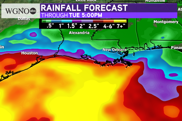
A weak front will move through and stall near the coast helping to draw moisture up to the area. However as TD 20 moves west it will start to take the moisture with it. So this will create a tight gradient of rainfall across the area.
High rainfall totals will be offshore over the Gulf but get progressively lower moving inland. Best chance of rain through early in the week will be south of I-10.
Right now we do not expect any issues with this system through early next week. However it will need to be watched over the next few days to determine where this eventually ends up. As always stay with WGNO for the latest.
Check out current conditions near you: https://digital-staging.wgno.com/weather/new-orleans-weather-radar/
Stay up to date with the latest forecast: digital-staging.wgno.com/weather/forecast/
Download the WGNO Weather App to stay connected this hurricane season


